GEI was the terrestrial and aquatic ecologist amongst a multi-disciplinary team of planners, engineers, fluvial geomorphologists, and landscape architects charged with designing and implementing one of the largest urban Natural Heritage Systems (NHS) in southern Ontario. The 528-ha community of Mount Pleasant Sub-Area 51-1 in Northwest Brampton provides homes to several thousands of residents. The NHS forms a green spine that is a central, organizing element in this new transit-friendly community.
Through years of detailed ecological investigations, GEI developed a clear and comprehensive understanding of the landscape functions and features that serve as the building blocks for a new and more robust NHS. GEI engaged with environmental regulators to understand their needs and to collaboratively develop a vision for a robust NHS.
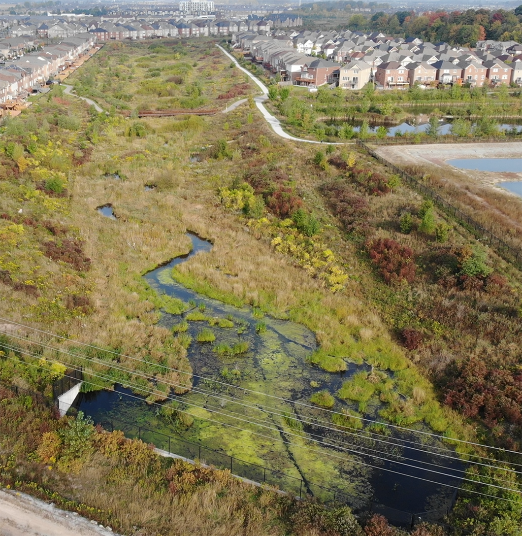
Before the project was started, less than 6% of the area was comprised of natural ecosystems, mostly consisting of isolated forests and wetlands. The main watercourse (East Huttonville Creek) and associated headwater drainage features were ditched and realigned to support agriculture. Now, following completion of the NHS, the project area contains a contiguous > 5km riparian and upland corridor that provides direct and contributing habitat for a range of aquatic and terrestrial life including the Federally and Provincially endangered Redside Dace, with portions of the created channel being designated as occupied Redside Dace habitat in 2017. The NHS connects and protects the created riparian corridor with significant and local woodlands and wetlands. Many of the created and restored wetlands in the NHS are now designated as provincially significant. GEI was responsible for the design of the NHS that protected, restored, and enhanced the diversity and connectivity of natural areas and features.
Trails, which residents use for travel to and from work, home, and play, were sited during conceptual and detailed design of the NHS. GEI provided ecological expertise on the trail network location to avoid and minimize impacts to the NHS. GEI determined the location and themes for each interpretative sign providing story text and photos for each sign and collaborating with the landscape architect on graphics. The trail network protects the sensitive features of the NHS while providing a pedestrian-friendly trail system for local residents. The integrated trail network carries residents by foot and bicycle from Mount Pleasant Go Station along the NHS, with interpretative signs along the way to stop and learn about the natural habitats present in their community. Trail viewpoints were created adjacent to key natural spaces and interpretative signs were developed to educate trail users on the ecologically valuable natural spaces and innovations used to realize this urban natural heritage system.
GEI and the project team developed and recently (2021) fulfilled the long-term monitoring program of the NHS which included baseline, during construction and performance monitoring. During the construction period weekly meetings and site walks were conducted with agency staff to review progress and also identify issues that arose which allowed for best management practices to be implemented with a solutions-based focus. Adaptive monitoring strategies were utilized within various portions of the NHS to address invasive species spread and to adjust to unexpected conditions such as Beaver dam creation and associated flooding, leading to the creation of new habitats, and altering the intended design of others. Collaborating with Credit Valley Conservation Authority (CVC), the Ministry of Natural Resources and Forestry (now NDMNRF) and the City of Brampton from project initiation in developing a Terms of Reference for the Environmental Implementation Report through to the final performance monitoring report submission was key to determining the NHS goals and objectives. This collaboration carried through the monitoring program to determine that the Mount Pleasant NHS is progressing along the intended trajectory for meeting these long-term restoration objectives.
GEI and the Mount Pleasant team have received several urban design awards for Mount Pleasant, including:
- International Making Cities Livable Award 2013.
- Brampton Urban Design Award 2012, Best Overall Project, Mount Pleasant Village New Neighbourhood, Brampton.
- Brampton Urban Design Award 2012, Award of Merit, Healthy and Sustainable Development, Mount Pleasant Village, Brampton.